Select one of our road trips to start your journey
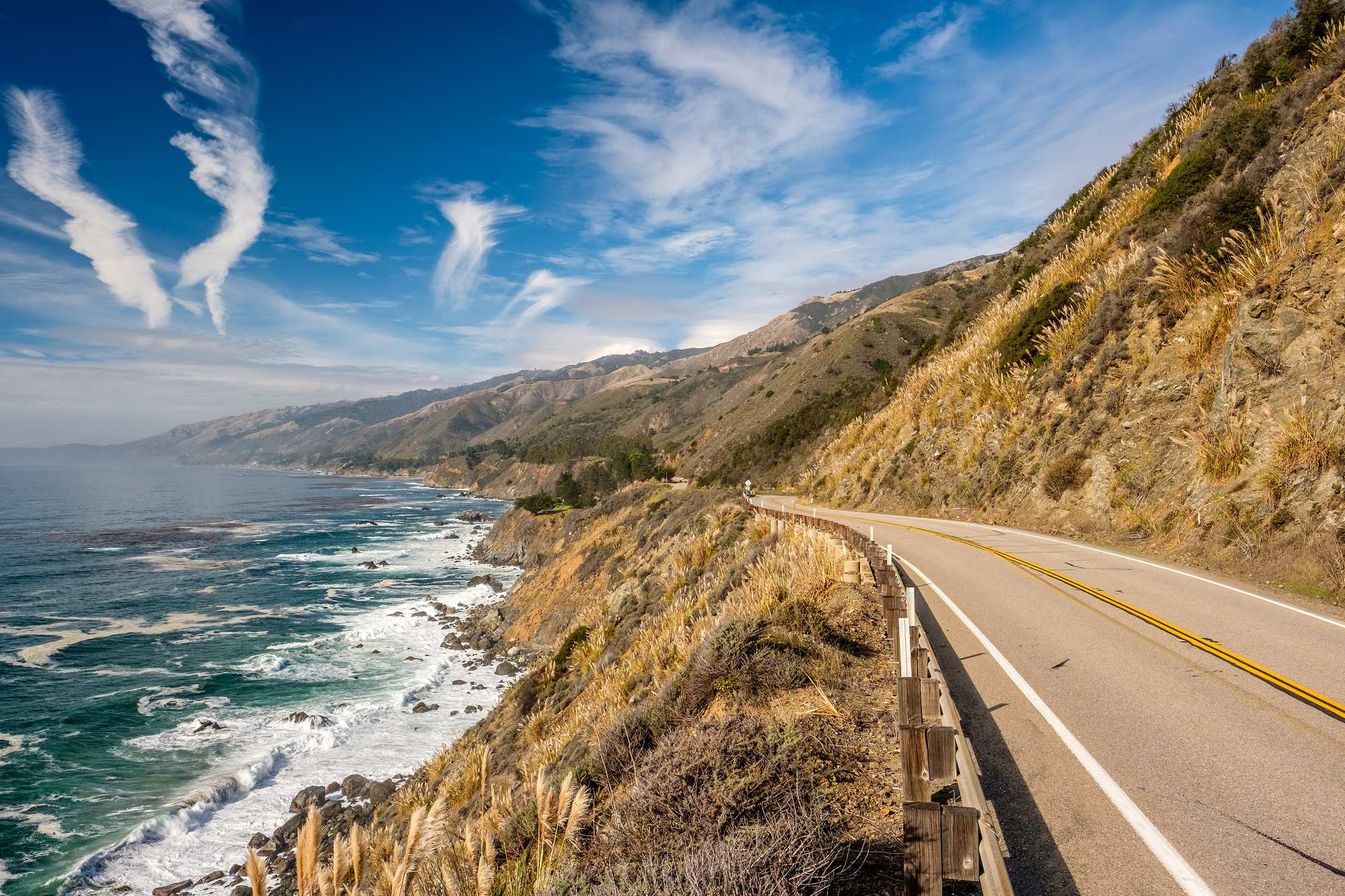
Pacific Coast Highway Road Trip
AAA Photo
0
leg -
miles:
hours,
min
California's SR 1, also called the Pacific Coast Highway, is one of the most sce...
Vegas to National Parks to Vegas Road Trip
AAA Photo
6
legs -
857.4 miles:
16 hours,
0 min
Any road trip through the Desert Southwest is full of unique twists and turns, r...
San Francisco to Yosemite National Park Road Trip
AAA Photo
4
legs -
587.6 miles:
13 hours,
23 min
Modern-day visitors embarking on a road trip through Yosemite National Park and ...
Route 66 - Western Arizona Road Trip
AAA Photo
3
legs -
244.7 miles:
5 hours,
37 min
One of the quintessential Route 66 states, Arizona boasts the longest stretch of...
California Desert Road Trip
AAA Photo
4
legs -
378.5 miles:
7 hours,
23 min
The granddaddy of SoCal desert resorts, Palm Springs has been attracting road-tr...
Los Angeles to Death Valley Road Trip
AAA Photo
4
legs -
573.8 miles:
10 hours,
20 min
Wind-swept sand dunes. Otherworldly badlands. Serpentine stone canyons. The geol...
Northern CA Wine Country Road Trip
AAA Photo
4
legs -
312.0 miles:
8 hours,
44 min
This twisting, turning route is full of sights, sounds, smells and tastes found ...
San Francisco to Lake Tahoe to Reno Road Trip
AAA Photo
3
legs -
486.3 miles:
9 hours,
14 min
Crossing California is always an adventure, and especially so when you depart th...
Eastern Sierra Road Trip
AAA Photo
4
legs -
761.8 miles:
14 hours,
19 min
One of California's most celebrated scenic drives, this adventure circles the sp...
Route 66 - Western California Road Trip
AAA Photo
3
legs -
63.0 miles:
3 hours,
27 min
Route 66 enthusiasts won’t want to miss this trip across southern California fro...
North Las Vegas Boulevard Road Trip
AAA Photo
1
leg -
3.1 miles:
0 hours,
15 min
While it may be tempting to head straight for the dazzling neon lights of the La...
Las Vegas Strip Road Trip
AAA Photo
4
legs -
9.8 miles:
0 hours,
59 min
The dazzling sights of the Las Vegas Strip are best enjoyed at night. This 4-mil...
Cape Royal Scenic Road Road Trip
AAA Photo
1
leg -
19.7 miles:
0 hours,
39 min
Seasonal route: The road is subject to closure in winter. The secluded North Rim...
Apache Trail Historic Scenic Byway Road Trip
AAA Photo
1
leg -
17.0 miles:
0 hours,
32 min
Apache Trail Historic Scenic Byway (SR 88) climbs a narrow trail up the 2,304-fo...
Sky Island Scenic Byway Road Trip
AAA Photo
0
leg -
miles:
hours,
min
From dusty scrub-brush-covered hills to rocky peaks dotted with pines, explore d...
Coronado Memorial Scenic Highway Road Trip
AAA Photo
1
leg -
8.2 miles:
0 hours,
19 min
This roughly 8-mile trip on the Coronado Memorial Highway in southeast Arizona b...
San Francisco Peaks Scenic Road Road Trip
AAA Photo
0
leg -
miles:
hours,
min
Beyond Flagstaff, US 180 passes through dense ponderosa pine and aspen forests n...
Ruby Scenic Road Road Trip
AAA Photo
1
leg -
10.4 miles:
0 hours,
17 min
Ruby Scenic Road (SR 289) ascends into the rugged Tumacacori Highlands past roll...
Organ Pipe Cactus National Monument Scenic Drive Road Trip
AAA Photo
1
leg -
27.5 miles:
0 hours,
26 min
Classic Southwest scenery dominates this drive on SR 85 through Organ Pipe Cactu...
Smith River Scenic Byway Road Trip
AAA Photo
1
leg -
36.0 miles:
0 hours,
45 min
California's northwestern corner is wilderness at its most magnificent, thanks t...
Santa Cruz Mountains Scenic Drive Road Trip
AAA Photo
1
leg -
34.1 miles:
1 hours,
4 min
In the greater San Francisco Bay Area, Santa Cruz Mountains Scenic Drive probabl...
Cascade Wonderland Scenic Highway Road Trip
AAA Photo
1
leg -
173.8 miles:
3 hours,
5 min
The stretch of I-5 beginning at the Oregon border, also known as the Cascade Won...
Volcanic Legacy Scenic Byway Road Trip
AAA Photo
1
leg -
137.1 miles:
2 hours,
47 min
Seasonal route: The road is subject to closure in winter. The Volcanic Legacy Sc...
Feather River Scenic Byway Road Trip
AAA Photo
1
leg -
60.1 miles:
1 hours,
11 min
Following the middle fork of the Feather River while climbing into the Sierra Ne...
American River Scenic Highway Road Trip
AAA Photo
0
leg -
miles:
hours,
min
US 50 leaves the flat Sacramento Valley behind as it enters the formidable Sierr...
Carson Pass Scenic Highway Road Trip
AAA Photo
1
leg -
55.1 miles:
1 hours,
6 min
Seasonal route: The road is subject to closure in winter. A stunning drive throu...
Monitor Pass Scenic Highway Road Trip
AAA Photo
0
leg -
miles:
hours,
min
Seasonal route: The road is subject to closure in winter. Two-lane SR 89 crosses...
Ebbetts Pass National Scenic Byway Road Trip
AAA Photo
1
leg -
0 miles:
0 hours,
0 min
Seasonal route: The road is subject to closure in winter. Crossing the rugged Si...
Tioga Pass Scenic Highway Road Trip
AAA Photo
1
leg -
92.2 miles:
2 hours,
11 min
Seasonal route: The road is subject to closure in winter. Traversing the norther...
Merced River Scenic Highway Road Trip
AAA Photo
0
leg -
miles:
hours,
min
The Merced River Scenic Highway (SR 140) is one of the main entrances into Yosem...
Wawona Scenic Road Road Trip
AAA Photo
1
leg -
52.5 miles:
1 hours,
43 min
Wawona Scenic Road (SR 41) winds through ever-thickening pine and oak forests wi...
Eastern Sierra Scenic Byway Road Trip
AAA Photo
1
leg -
132.8 miles:
2 hours,
15 min
Seasonal route: The road is subject to closure in winter. Running along the east...
Kings Canyon Scenic Byway Road Trip
AAA Photo
1
leg -
36.3 miles:
1 hours,
0 min
Seasonal route: The road is subject to closure in winter. The only vehicle route...
Generals Scenic Highway Road Trip
AAA Photo
0
leg -
miles:
hours,
min
Seasonal route: The road is subject to closure in winter. Named for two of the s...
Amargosa Range Scenic Highway Road Trip
AAA Photo
1
leg -
61.1 miles:
1 hours,
6 min
Southern California's Death Valley is isolation exemplified. The austere desert ...
17 Mile Scenic Drive Road Trip
AAA Photo
1
leg -
16.1 miles:
0 hours,
51 min
As scenic drives go, this one definitely does not disappoint. Hugging the Monter...
Angeles Crest Scenic Highway Road Trip
AAA Photo
0
leg -
miles:
hours,
min
Seasonal route: The road is subject to closure in winter. Angeles Crest Highway ...
Rim of the World Scenic Drive Road Trip
AAA Photo
1
leg -
46.9 miles:
1 hours,
19 min
Say "Southern California" and most people think palm trees and beaches. Experien...
Palms to Pines Scenic Byway Road Trip
AAA Photo
1
leg -
36.7 miles:
0 hours,
45 min
In a span of just under 40 miles on SR 74 in the San Bernardino National Forest,...
Mulholland Scenic Highway Road Trip
AAA Photo
1
leg -
32.4 miles:
1 hours,
0 min
Beginning in the L.A. suburbs, Mulholland Scenic Highway twists and turns throug...
Trinity Scenic Byway Road Trip
AAA Photo
1
leg -
130.8 miles:
2 hours,
33 min
The stretch of SR 299 known as the Trinity Scenic Byway is one of Northern Calif...
Borrego Salton Scenic Seaway Road Trip
AAA Photo
1
leg -
16.4 miles:
18 hours,
0 min
The badlands of southeastern California's Anza-Borrego Desert State Park are the...
Avenue of the Giants Scenic Highway Road Trip
AAA Photo
1
leg -
60.5 miles:
1 hours,
25 min
Drive the Avenue of the Giants Scenic Highway surrounded by the tallest trees in...
Sunset Cliffs Scenic Boulevard Road Trip
AAA Photo
1
leg -
1.4 miles:
0 hours,
5 min
The sun setting over the Pacific is almost guaranteed to produce a visual specta...
Reese River Valley Scenic Drive Road Trip
AAA Photo
1
leg -
87.0 miles:
1 hours,
20 min
Uninhabited and starkly scenic, the 90-mile stretch of SR 305 cuts through the v...
Ruby Lake National Wildlife Refuge Scenic Drive Road Trip
AAA Photo
0
leg -
miles:
hours,
min
Excellent wildlife photo opportunities await you at Ruby Lake National Wildlife ...
Lake Tahoe Eastshore Drive National Scenic Byway Road Trip
AAA Photo
1
leg -
16.8 miles:
0 hours,
29 min
The Lake Tahoe Eastshore Drive (SR 28) dazzles the sightseer. The lake, sparklin...
Kingsbury Grade Scenic Road Road Trip
AAA Photo
0
leg -
miles:
hours,
min
Ranch lands in Carson Valley rise to greet the steep Carson Mountain Range of th...
Mount Rose National Scenic Byway Road Trip
AAA Photo
1
leg -
23.7 miles:
0 hours,
31 min
As you navigate the Mount Rose Scenic Byway (SR 431), snow-dusted mountains loom...
Amargosa Desert Scenic Route 374 Road Trip
AAA Photo
1
leg -
16.6 miles:
0 hours,
25 min
Amargosa Desert Scenic Route 374 is a 16-mile drive in southern Nevada between B...
Spring Mountains Scenic Drive Road Trip
AAA Photo
0
leg -
miles:
hours,
min
The Spring Mountains Scenic Drive, in the Humboldt-Toiyabe National Forest near ...
Mt. Wilson Backcountry Scenic Byway Road Trip
AAA Photo
0
leg -
miles:
hours,
min
Experience expansive vistas in every direction as you travel the Mt. Wilson Back...
Big Smoky Valley Scenic Drive Road Trip
AAA Photo
1
leg -
99.9 miles:
1 hours,
25 min
The Big Smoky Valley Scenic Drive (SR 376) bisects the Humboldt-Toiyabe National...
Wheeler Peak Scenic Drive Road Trip
AAA Photo
1
leg -
13.7 miles:
0 hours,
30 min
The Wheeler Peak Scenic Drive lifts you to incredible heights above the state in...
Chuckanut Drive Scenic Byway Road Trip
AAA Photo
1
leg -
21.2 miles:
0 hours,
33 min
Carved into a rocky hillside, two-lane Chuckanut Drive features steep slopes and...
North Cascades Scenic Highway Road Trip
AAA Photo
1
leg -
103.8 miles:
2 hours,
3 min
Seasonal route: The road is subject to closure in winter. This astounding route ...
North Coulee Corridor Scenic Byway Road Trip
AAA Photo
1
leg -
28.4 miles:
0 hours,
33 min
SR 155 passes by one of the largest concrete structures in the world, the Grand ...
Clarkston to Oregon Scenic Drive Road Trip
AAA Photo
1
leg -
42.1 miles:
1 hours,
1 min
The views along SR 129 are as varied as they are breathtaking - from twists and ...
Whidbey Scenic Isle Way Road Trip
AAA Photo
1
leg -
49.2 miles:
1 hours,
11 min
Two state parks, Mukilteo and Deception Pass, are excellent locations to enjoy v...
Mountain Loop Scenic Highway Road Trip
AAA Photo
1
leg -
44.2 miles:
1 hours,
30 min
This byway cuts through dense, shady woodland on its way to the heart of the wes...
Spirit Lake Memorial Scenic Highway Road Trip
AAA Photo
0
leg -
miles:
hours,
min
Seasonal route: The road is subject to closure in winter. Witness the power of n...
Yakima Scenic Byway Road Trip
AAA Photo
1
leg -
58.5 miles:
0 hours,
58 min
North-south US 97 traverses several states; on this portion, you'll cut across s...
North Shore Columbia River Gorge National Scenic Byway Road Trip
AAA Photo
1
leg -
66.5 miles:
1 hours,
18 min
The mighty Columbia River flows 1,243 miles from its headwaters in British Colum...
Lewis & Clark Trail Scenic Drive Road Trip
AAA Photo
1
leg -
20.0 miles:
0 hours,
23 min
On SR 4 you will travel along the Washington shoreline of the Columbia River. Ne...
Pacific Coast Scenic Byway, Lake Crescent Area Road Trip
AAA Photo
0
leg -
miles:
hours,
min
Spanning the northern boundary of Olympic National Park on the Olympic Peninsula...
Pacific Coast Scenic Byway, Hood Canal Area Road Trip
AAA Photo
1
leg -
21.7 miles:
0 hours,
27 min
The eastern side of Washington's Olympic Peninsula is outside the boundary of Ol...
Hood Canal Scenic Route Road Trip
AAA Photo
1
leg -
15.0 miles:
0 hours,
22 min
The Hood Canal Scenic Route (SR 106) traces the lower extension of the L-shaped ...
Sunrise Scenic Road Road Trip
AAA Photo
0
leg -
miles:
hours,
min
Seasonal route: The road is subject to closure in winter. Sunrise Road features ...
Windy Ridge Scenic Highway Road Trip
AAA Photo
0
leg -
miles:
hours,
min
Seasonal route: The road is subject to closure in winter. In May 1980, Mount St....
Canyon de Chelly Scenic Rim Drive Road Trip
AAA Photo
1
leg -
34.4 miles:
0 hours,
41 min
Entirely within the Navajo Nation, Canyon de Chelly National Monument boasts a b...
Arizona's Scenic Chiricahua Mountain Range Road Trip
AAA Photo
0
leg -
miles:
hours,
min
Travel across remote desert lands into bare mountains rising in the distance on ...
Beeline Scenic Highway Road Trip
AAA Photo
1
leg -
72.0 miles:
1 hours,
8 min
Beeline Scenic Highway (SR 87) through Tonto National Forest climbs from the rug...