Landscape
Fjordland
The Northern Fjords
Traveling in Norway
The Norwegians
The Viking Settlers
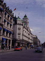
Downtown Oslo
The broad southwestern half of the country is known as Sørlandet, the South Country. Here, on the coastal fringe and around Oslo, is lowland Norway, where the sheltered coast is a favorite vacation destination for Norwegian families - a landscape of mellow woods and fields and tranquil blue waters. On the southern tip of Sørlandet is the sunny town of Kristiansand, with its flock of offshore islands. Southwest along the coast is Mandal, where attractive beaches catch the best of the summer sun; nearby is the promontory of Lindesnes, whose fyr (lighthouse) marks Norway's southernmost point.
Then the coast turns to the northwest, twisting through a rugged landscape of rocky headlands and deeply indented fjords, past the pleasant town of Egersund and finally through rich farming country to Stavanger and the open west.
| COUNTRY |
| Introduction |
| Things To Know |
| Survival Guide |
| TimeLine |
| Essential Info |
| REGION |
| CITIES |
| Oslo |
| MAPS |
| World |
| Europe |
| TRAVEL BOOK |
 |